-
Title
-
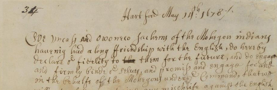
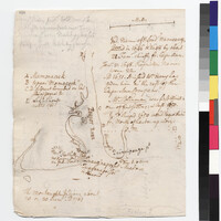
Stiles' Map of the Pequot River
-
Creator
-
Stiles, Ezra, 1727-1795 (Author)
-
Type of Resource
-
text
-
Collection
-
Beinecke Library; Yale Indian Papers Project
-
Language
-
English
-
Rights
-
The use of this image may be subject to the copyright law of the United States (Title 17, United States Code) or to site license or other rights management terms and conditions. The person using the image is liable for any infringement
-
Digcoll
-
digcoll:2564620
-
Funding Source
-
National Endowment for the Humanities (NEH)
-
Other Dates
-
1646 (Mentioned); 1648 (Mentioned); 1651 (Mentioned); c. 1650 (Mentioned); January 23, 1648 (Mentioned)
-
Original Repository
-
Beinecke Library, Yale University
-
Tribe
-
Montauk; Narragansett; Pequot
-
Associated Names
-
Blinman, Richard (Mentioned within document); Keeney, William (Mentioned within document); Niles (Narrag), Samuel, -1785 (Mentioned within document); Unknown (Recipient)
-
Date Created
-
October 1761
-
Date
-
October 1761
-
Topics
-
Buildings/Structures -- Lighthouses; Census/Enumerations -- Private/Informal; Geography -- Map/Survey; Geography -- Place Names; Land -- Conveyances -- Grants; Landforms -- Aquatic -- Rivers; Landforms -- Terrestrial -- Islands; Landforms -- Terrestrial -- Meadows; Landforms -- Terrestrial -- Seashore; Language -- Algonquian -- Eastern -- Narragansett; Military -- Forts; Repository -- Yale University -- Beinecke Library; Tribes/Communities -- Montauk; Tribes/Communities -- Narragansett; Tribes/Communities -- Pequot; YIPP -- Colony of Connecticut Collection, 1603-1783
-
Place
-
North America -- British Empire -- Colony of Connecticut -- Groton -- Mamacoke; North America -- British Empire -- Colony of Connecticut -- Groton -- Pine Island; North America -- British Empire -- Colony of Connecticut -- Groton -- Quinnipeage Point; North America -- British Empire -- Colony of Connecticut -- Groton -- Shenecossett; North America -- British Empire -- Colony of Connecticut -- New London -- Fort Hill; North America -- British Empire -- Colony of Connecticut -- New London -- New London Light; North America -- British Empire -- Colony of Connecticut -- New London -- Quaganpoxet; North America -- British Empire -- Colony of Connecticut -- New London; North America -- British Empire -- Colony of Connecticut -- Thames River; North America -- British Empire -- Province of Massachusetts Bay -- Cape Ann; North America -- British Empire -- Province of New York -- Fishers Island; North America -- Indian Country -- Pequot Territory -- Mamacoke; North America -- Indian Country -- Pequot Territory -- Nameag -- Fort Hill; North America -- Indian Country -- Pequot Territory -- Nameag -- Quaganpoxet; North America -- Indian Country -- Pequot Territory -- Nameag; North America -- Indian Country -- Pequot Territory -- Pequot River; North America -- Indian Country -- Pequot Territory -- Shenecossett; North America -- United States of America -- Commonwealth of Massachusetts -- Cape Ann; North America -- United States of America -- State of Connecticut -- Groton -- Mamacoke; North America -- United States of America -- State of Connecticut -- Groton -- Pine Island; North America -- United States of America -- State of Connecticut -- Groton -- Quinnipeage Point; North America -- United States of America -- State of Connecticut -- Groton -- Shenecossett; North America -- United States of America -- State of Connecticut -- New London -- Fort Hill; North America -- United States of America -- State of Connecticut -- New London -- New London Light; North America -- United States of America -- State of Connecticut -- New London -- Quaganpoxet; North America -- United States of America -- State of Connecticut -- New London; North America -- United States of America -- State of Connecticut -- Thames River; North America -- United States of America -- State of New York -- Fishers Island; Unknown
-
Identifier
-
15481085
-
number
-
1761.10.00.36