-
Title
-
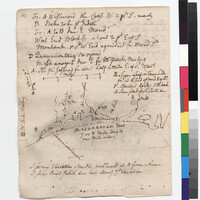
Stiles' Map of Charlestown and South Kingstown, Rhode Island
-
Creator
-
Stiles, Ezra, 1727-1795 (Author)
-
Type of Resource
-
text
-
Collection
-
Beinecke Library; Yale Indian Papers Project
-
Language
-
English
-
Rights
-
The use of this image may be subject to the copyright law of the United States (Title 17, United States Code) or to site license or other rights management terms and conditions. The person using the image is liable for any infringement
-
Digcoll
-
digcoll:2564638
-
Funding Source
-
National Endowment for the Humanities (NEH)
-
Original Repository
-
Beinecke Library, Yale University
-
Tribe
-
Narragansett; Niantic, Eastern
-
Associated Names
-
Champlin, Christopher, Col (Mentioned within document); Park, Joseph, Rev (Mentioned within document); Stanton, Joseph, Col., 1739-1882 (Mentioned within document); Unknown (Recipient)
-
Date Created
-
October 1761
-
Date
-
October 1761
-
Topics
-
Culture -- Place -- Culturally Significant Location; Culture -- Rites/Ceremonies -- Culturally Significant Location; Food/Drink -- Shellfish -- Shells; Geography -- Map/Survey; Geography -- Place Names; Landforms -- Aquatic -- Coves; Landforms -- Aquatic -- Ponds; Landforms -- Terrestrial -- Hills; Landforms -- Terrestrial -- Islands; Landforms -- Terrestrial -- Rocks/Rock Formations; Landforms -- Terrestrial -- Seashore; Repository -- Yale University -- Beinecke Library; Tribes/Communities -- Narragansett; Tribes/Communities -- Niantic -- Eastern; YIPP -- Colony of Rhode Island Collection, 1600-1783
-
Place
-
North America -- British Empire -- Colony of Rhode Island -- Block Island; North America -- British Empire -- Colony of Rhode Island -- Charlestown -- Bastard Rocks; North America -- British Empire -- Colony of Rhode Island -- Charlestown -- Mashonaug Island; North America -- British Empire -- Colony of Rhode Island -- Charlestown -- Mr. Park's Meeting House; North America -- British Empire -- Colony of Rhode Island -- Charlestown; North America -- British Empire -- Colony of Rhode Island -- New Shoreham; North America -- British Empire -- Colony of Rhode Island -- Point Judith; North America -- British Empire -- Colony of Rhode Island -- South Kingston -- Green Hills; North America -- British Empire -- Colony of Rhode Island -- South Kingston -- Sugarloaf Hill; North America -- British Empire -- Colony of Rhode Island -- Westerly -- Quanacontaug; North America -- British Empire -- Province of New York -- Long Island -- Montauk; North America -- Indian Country -- Manisses Territory -- Manisses; North America -- Indian Country -- Montauk Territory; North America -- Indian Country -- Narragansett Territory -- Bastard Rocks; North America -- Indian Country -- Narragansett Territory -- Mashonaug Island; North America -- Indian Country -- Narragansett Territory -- Quanacontaug; North America -- United States of America -- State of New York -- Long Island -- Montauk; North America -- United States of America -- State of Rhode Island -- Block Island; North America -- United States of America -- State of Rhode Island -- Charlestown -- Bastard Rocks; North America -- United States of America -- State of Rhode Island -- Charlestown -- Mr. Park's Meeting House; North America -- United States of America -- State of Rhode Island -- Charlestown -- Pauwaget Pond; North America -- United States of America -- State of Rhode Island -- Charlestown; North America -- United States of America -- State of Rhode Island -- New Shoreham; North America -- United States of America -- State of Rhode Island -- Point Judith; North America -- United States of America -- State of Rhode Island -- South Kingston -- Green Hills; North America -- United States of America -- State of Rhode Island -- South Kingston -- Sugarloaf Hill; North America -- United States of America -- State of Rhode Island -- Westerly -- Quanacontaug
-
Identifier
-
15481075
-
number
-
1761.10.00.20